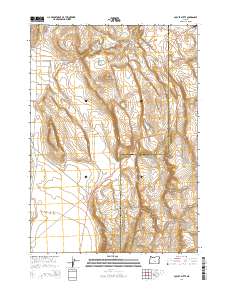
2014 Map of Locust Butte
USGS Topo · Published 2014About this map
Locust Butte rises from the high desert terrain of the Oregon interior, serving as a central landmark for this sparsely populated region of Harney and Lake counties. This 2014 survey captures a landscape defined by its water management and transportation corridors, where essential resources are marked by Locust Butte Reservoir and several livestock-critical sites such as Highway Lake Waterhole and Shroder Waterhole. The map illustrates the meeting of key regional transit routes, including the Lakeview-Burns Hwy and the Christmas Valley Hwy. To the northeast, the isolated Wagontire Airport provides a remote aviation waypoint, while the drainage of Lower Venator Crk snakes through the southern portion of the quadrangle. The survey provides an exacting look at the Public Land Survey System grid, highlighting the boundary between Lake and Harney counties as it cuts through the sagebrush and basin landscape.
Find a feature on this map
19 named features on this map. Tap any name to fly to it.
Don’t see what you’re looking for? This feature index may not catch every label — zoom into the map to look around manually.
Map Details
Editions of this 2014 Locust Butte Map
This is the sole edition of this map. No revisions or reprints were ever made.
Other maps of this area

1955 · Crescent
USGS Topo · 1:250,000

1955 · Burns
USGS Topo · 1:250,000

1957 · Crescent
USGS Topo · 1:250,000

1958 · Crescent
USGS Topo · 1:250,000

1958 · Burns
USGS Topo · 1:250,000

1959 · Burns
USGS Topo · 1:250,000

1970 · Crescent
USGS Topo · 1:250,000

1980 · Wagontire Mtn West
USGS Topo · 1:24,000

1980 · Wagontire Mtn East
USGS Topo · 1:24,000
1981 · Rams Butte
USGS Topo · 1:24,000