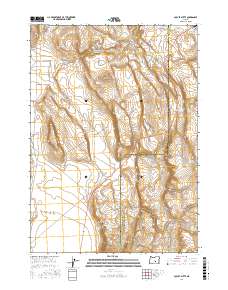
2017 Map of Locust Butte
USGS Topo · Published 2017About this map
Locust Butte rises above the high desert floor on the border of Harney and Lake counties, serving as the central landmark for this arid expanse. The landscape is defined by its water management, where remote catchments like Locust Butte Reservoir and Wolter Lake provide vital resources in a rain-shadow environment. A network of unpaved tracks, including Wagontire Lo Rd and Butte Valley Rd, crisscrosses the terrain, linking isolated waterholes such as Shroder Waterhole and Toms Waterhole. In the northeast corner, the Wagontire Airport stands as a lonely outpost of infrastructure, illustrating the vast distances and specialized transportation needs of this sparsely populated region. The transition between t27s r23e and surrounding townships reveals a grid system imposed upon a complex series of volcanic ridges and depressions.
Find a feature on this map
16 named features on this map. Tap any name to fly to it.
Don’t see what you’re looking for? This feature index may not catch every label — zoom into the map to look around manually.
Map Details
Editions of this 2017 Locust Butte Map
This is the sole edition of this map. No revisions or reprints were ever made.
Other maps of this area

1955 · Crescent
USGS Topo · 1:250,000

1955 · Burns
USGS Topo · 1:250,000

1957 · Crescent
USGS Topo · 1:250,000

1958 · Crescent
USGS Topo · 1:250,000

1958 · Burns
USGS Topo · 1:250,000

1959 · Burns
USGS Topo · 1:250,000

1970 · Crescent
USGS Topo · 1:250,000

1980 · Wagontire Mtn West
USGS Topo · 1:24,000

1980 · Wagontire Mtn East
USGS Topo · 1:24,000
1981 · Rams Butte
USGS Topo · 1:24,000