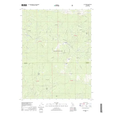
2018 Map of Log Spring
USGS Topo · Published 2018About this map
Mendocino National Forest defines the character of this 2018 survey, which straddles the high-elevation boundary between Tehama and Glenn Counties. The terrain is a complex network of ridges and glades, where water sources like Log Spring and Blackjack Spring provided critical infrastructure for early forest management and grazing. The settlement at Sunnyside represents the primary human foothold in an area otherwise dominated by geographical features such as Kenny Ridge and Lantz Ridge. Distinctive local nomenclature is evident in names like Hokey Pokey Ridge and Mule Spike, reflecting the historical usage of pack animals and specialized labor in these mountains. The presence of Powell Cabin and various forest roads, including Recer Ridge and the Paskenta-Mendocino Pass, suggests a landscape organized around seasonal movement and forestry operations.
Find a feature on this map
57 named features on this map. Tap any name to fly to it.
Don’t see what you’re looking for? This feature index may not catch every label — zoom into the map to look around manually.
Map Details
Editions of this 2018 Log Spring Map
This is the sole edition of this map. No revisions or reprints were ever made.
Other maps of this area

1919 · Elk Creek
USGS Topo · 1:62,500

1948 · Elk Creek
USGS Topo · 1:62,500

1952 · Paskenta
USGS Topo · 1:62,500

1952 · Hull Mountain
USGS Topo · 1:62,500

1952 · Anthony Peak
USGS Topo · 1:62,500

1957 · Elk Creek
USGS Topo · 1:62,500

1957 · Ukiah
USGS Topo · 1:250,000

1960 · Ukiah
USGS Topo · 1:250,000

1967 · Plaskett Ridge
USGS Topo · 1:24,000
1967 · Plaskett meadows
USGS Topo · 1:24,000