
1904 Map of Logan Creek
USGS Topo · Published 1956About this map
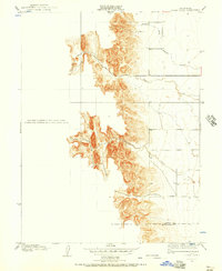
Logan Creek and its tributaries define the transition from the flat agricultural plains of the Sacramento Valley into the steep foothills of the Inner Coast Range. This 1904 survey, conducted under E.M. Douglas and R.B. Marshall, captures the drainage patterns of North Fork Logan Creek and Hunters Creek before modern water management significantly altered the regional hydrology. The map clearly delineates the Glenn Co and Colusa Co boundary as it crosses the rugged topography. While the western half of the sheet is dominated by dense contour lines indicating sharp elevation gains, the eastern section shows the early road network and section lines that guided early ranching and land division in this part of California.
Find a feature on this map
4 named features on this map. Tap any name to fly to it.
Don’t see what you’re looking for? This feature index may not catch every label — zoom into the map to look around manually.
Map Details
Editions of this 1904 Logan Creek Map
2 editions found
Other maps of this area

1904 · Sites
USGS Topo · 1:24,000

1906 · Maxwell
USGS Topo · 1:62,500

1906 · Willows
USGS Topo · 1:62,500

1917 · Kurand
USGS Topo · 1:31,680

1917 · Lyman
USGS Topo · 1:31,680

1917 · Logandale
USGS Topo · 1:31,680

1917 · Sites
USGS Topo · 1:31,680

1917 · Delevan
USGS Topo · 1:31,680

1918 · Logan Creek
USGS Topo · 1:31,680

1919 · Fruto
USGS Topo · 1:62,500