
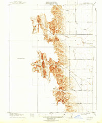
1918 Map of Logan Creek
USGS Topo · Published 1918About this map
Logan Creek and its northern drainage pattern define this California landscape during the early twentieth century. This preliminary edition survey captures the sharp topographical transition from the steep upland ridges to the flatter alluvial terrain typical of the Sacramento Valley's western edge. The drainage network, featuring North Fork Logan Creek and Hunters Creek, demonstrates the natural water flow through the foothills before reaching the cultivated valley floors. Along the southern edge of the map, the political boundary between Glenn Co and Colusa Co is clearly marked, providing a precise reference point for historical property research and local genealogy. Several bench marks, including BM 173 and BM 189, are strategically placed along early road paths, indicating the progress of precise surveying and infrastructure development in this rural agricultural district.
Find a feature on this map
12 named features on this map. Tap any name to fly to it.
Don’t see what you’re looking for? This feature index may not catch every label — zoom into the map to look around manually.
Map Details
Editions of this 1918 Logan Creek Map
2 editions found
Other maps of this area

1904 · Logan Creek
USGS Topo · 1:24,000

1904 · Sites
USGS Topo · 1:24,000

1906 · Maxwell
USGS Topo · 1:62,500

1906 · Willows
USGS Topo · 1:62,500

1917 · Kurand
USGS Topo · 1:31,680

1917 · Lyman
USGS Topo · 1:31,680

1917 · Logandale
USGS Topo · 1:31,680

1917 · Sites
USGS Topo · 1:31,680

1917 · Delevan
USGS Topo · 1:31,680

1919 · Fruto
USGS Topo · 1:62,500