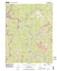
1996 Map of Logan
USGS Topo · Published 2002About this map
The Guyandotte River carves a deep, winding path through the center of this landscape, its banks lined with the tight-knit coal and rail communities of Logan, Stollings, and McConnell. This 1996 survey reflects an era of intensive land use, where the traditional valley settlements are hemmed in by steep slopes and significant Strip Mine activity on the high ridges. The map captures the dense cultural footprint of the Island Creek drainage, showing a string of towns like Monaville and Rossmore that follow the narrow corridor of the creek. Genealogists will find numerous small landmarks, including the Sunbeam Chapel, Gore Cem, and Mullens Cem. The industrial character of the region is evident in the network of conveyors and air shafts supporting mining operations near Rita and Earling, while the high elevation at Rattlesnake Knob offers a perspective on the area's complex topography.
Find a feature on this map
87 named features on this map. Tap any name to fly to it.
Don’t see what you’re looking for? This feature index may not catch every label — zoom into the map to look around manually.
Map Details
Editions of this 1996 Logan Map
This is the sole edition of this map. No revisions or reprints were ever made.
Other maps of this area

1887 · Warfield
USGS Topo · 1:125,000

1891 · Oceana
USGS Topo · 1:125,000

1891 · Warfield
USGS Topo · 1:125,000

1893 · Oceana
USGS Topo · 1:125,000

1898 · Oceana
USGS Topo · 1:125,000

1909 · Matewan
USGS Topo · 1:48,000

1909 · Gilbert
USGS Topo · 1:48,000

1910 · Holden
USGS Topo · 1:48,000

1912 · Gilbert
USGS Topo · 1:62,500

1912 · Holden
USGS Topo · 1:62,500