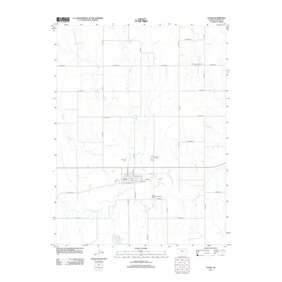
2012 Map of Logan
USGS Topo · Published 2012About this map
The N Fork Solomon River defines the southern reach of this Kansas landscape, where the town of Logan serves as a central hub for the surrounding agricultural district. The town's grid is anchored by W Main St and Walnut St, with the municipal Logan Wastewater Treatment Facility situated along the riverbank. This map captures a significant record for genealogists, detailing three distinct burial sites: the Old Logan Cem near the town center, Pleasant View Cem to the east, and the Saint Peters Evangelical Lutheran Cem further north. The drainage patterns are clearly marked by the winding paths of Crooked Cr, Beaver Cr, and Wolf Cr, which feed toward the main river valley. To the southwest, the Logan City Lake provides a localized water feature amidst the section-line road network.
Find a feature on this map
36 named features on this map. Tap any name to fly to it.
Don’t see what you’re looking for? This feature index may not catch every label — zoom into the map to look around manually.
Map Details
Editions of this 2012 Logan Map
This is the sole edition of this map. No revisions or reprints were ever made.
Other maps of this area

1893 · Norton
USGS Topo · 1:125,000

1893 · Phillipsburg
USGS Topo · 1:125,000

1955 · Beloit
USGS Topo · 1:250,000

1959 · Beloit
USGS Topo · 1:250,000

1972 · Speed
USGS Topo · 1:24,000

1972 · Glade SW
USGS Topo · 1:24,000
1973 · Stuttgart
USGS Topo · 1:24,000

1978 · Logan
USGS Topo · 1:24,000
1978 · Densmore
USGS Topo · 1:24,000
1978 · Prairie View
USGS Topo · 1:24,000