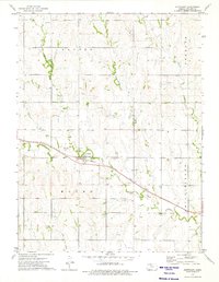
1973 Map of Stuttgart
USGS Topo · Published 1975About this map
Stuttgart serves as the central hub of this northern Kansas landscape, situated at the intersection of the Chicago Rock Island and Pacific railroad and local thoroughfares. The 1970s terrain is characterized by a significant petroleum presence, with an extensive Oil Field and numerous scattered oil wells appearing across the townships of Dayton, Freedom, and Phillips Burg. These industrial markers sit alongside traditional agricultural land use, evidenced by the many quarries and a Sandpit noted in the northern sections.
Find a feature on this map
19 named features on this map. Tap any name to fly to it.
Don’t see what you’re looking for? This feature index may not catch every label — zoom into the map to look around manually.
Map Details
Editions of this 1973 Stuttgart Map
This is the sole edition of this map. No revisions or reprints were ever made.
Other maps of this area

1893 · Norton
USGS Topo · 1:125,000

1893 · Phillipsburg
USGS Topo · 1:125,000

1955 · Beloit
USGS Topo · 1:250,000

1959 · Beloit
USGS Topo · 1:250,000
1967 · Long Island
USGS Topo · 1:24,000

1968 · Woodruff
USGS Topo · 1:24,000

1972 · Speed
USGS Topo · 1:24,000

1972 · Phillipsburg South
USGS Topo · 1:24,000

1973 · Stuttgart NE
USGS Topo · 1:24,000
1973 · Phillipsburg North
USGS Topo · 1:24,000