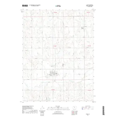
2018 Map of Logan
USGS Topo · Published 2018About this map
Logan serves as the focal point of this North Central Kansas landscape, situated near the confluence of local drainage systems and the N Fork Solomon River. The town's grid is clearly defined by streets like Commercial St and W Main St, reflecting its role as a regional center for the surrounding agricultural community. The map provides a detailed view of the rural cemetery network, including Saint Peters Evangelical Lutheran Cem to the north and the Old Logan Cem closer to the town site. The physical geography is dominated by a series of creeks, such as Beaver Cr and Crooked Cr, which carve through the high plains before reaching the river valley. To the south, Logan City Lake provides a localized water feature amidst the expansive township and range sections that define this portion of Phillips County.
Find a feature on this map
30 named features on this map. Tap any name to fly to it.
Don’t see what you’re looking for? This feature index may not catch every label — zoom into the map to look around manually.
Map Details
Editions of this 2018 Logan Map
This is the sole edition of this map. No revisions or reprints were ever made.
Other maps of this area

1893 · Norton
USGS Topo · 1:125,000

1893 · Phillipsburg
USGS Topo · 1:125,000

1955 · Beloit
USGS Topo · 1:250,000

1959 · Beloit
USGS Topo · 1:250,000

1972 · Speed
USGS Topo · 1:24,000

1972 · Glade SW
USGS Topo · 1:24,000
1973 · Stuttgart
USGS Topo · 1:24,000

1978 · Logan
USGS Topo · 1:24,000
1978 · Densmore
USGS Topo · 1:24,000
1978 · Prairie View
USGS Topo · 1:24,000