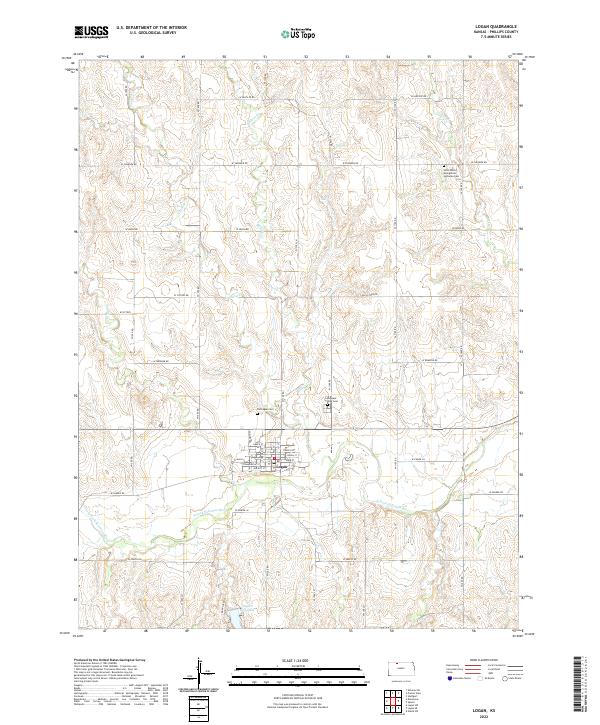
2022 Map of Logan
USGS Topo · Published 2022About this map
The town of Logan serves as the focal point of this Phillips County survey, situated just north of the meandering N Fork Solomon River. The landscape is defined by a dendritic drainage network where waterways like Crooked Cr, Beaver Cr, and Cactus Cr carve through the plains toward the river valley. Local history is anchored by several distinct burial sites, including the Old Logan Cem near the town center and the Saint Peters Evangelical Lutheran Cem to the northeast. To the south, Logan City Lake provides a localized water feature amidst the agricultural sections. The map's grid of roads, such as W Santa Fe Rd and W Zenith Rd, reflects the structured section lines of the Public Land Survey System that govern the region's geography.
Find a feature on this map
33 named features on this map. Tap any name to fly to it.
Don’t see what you’re looking for? This feature index may not catch every label — zoom into the map to look around manually.
Map Details
Editions of this 2022 Logan Map
This is the sole edition of this map. No revisions or reprints were ever made.
Other maps of this area

1893 · Norton
USGS Topo · 1:125,000

1893 · Phillipsburg
USGS Topo · 1:125,000

1955 · Beloit
USGS Topo · 1:250,000

1959 · Beloit
USGS Topo · 1:250,000

1972 · Speed
USGS Topo · 1:24,000

1972 · Glade SW
USGS Topo · 1:24,000
1973 · Stuttgart
USGS Topo · 1:24,000

1978 · Logan
USGS Topo · 1:24,000
1978 · Densmore
USGS Topo · 1:24,000
1978 · Prairie View
USGS Topo · 1:24,000