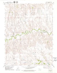
1979 Map of Logan SE
USGS Topo · Published 1979About this map
Bow Creek meanders through the heart of this landscape, defining the rural boundary between Phillips and Rooks Counties and briefly touching Graham County. This 1970s survey captures a transition in Kansas land use, where the open prairie of Plainview and the Pioneer Field are marked by agricultural development and early-century infrastructure. The small community of Towanda serves as a local anchor, while the Prairie Dale Cem provides a specific point of interest for genealogists tracing local families in this tri-county corner. Industrial footprints are visible in the northern section, where the Towanda Field and a nearby Radio Tower stand out against the agricultural grid. To the north, Logan City Lake serves as a primary water feature, contrasting with the seasonal drainage patterns of Sand Creek in the south.
Find a feature on this map
14 named features on this map. Tap any name to fly to it.
Don’t see what you’re looking for? This feature index may not catch every label — zoom into the map to look around manually.
Map Details
Editions of this 1979 Logan SE Map
This is the sole edition of this map. No revisions or reprints were ever made.
Other maps of this area

1893 · Norton
USGS Topo · 1:125,000

1893 · Phillipsburg
USGS Topo · 1:125,000

1893 · Hill
USGS Topo · 1:125,000

1896 · Plainville
USGS Topo · 1:125,000

1952 · Webster Dam
USGS Topo · 1:24,000

1955 · Beloit
USGS Topo · 1:250,000

1959 · Beloit
USGS Topo · 1:250,000

1969 · Nicodemus
USGS Topo · 1:24,000

1972 · Speed
USGS Topo · 1:24,000

1972 · Glade SW
USGS Topo · 1:24,000