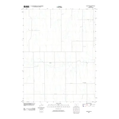
2009 Map of Logan SW
USGS Topo · Published 2009About this map
Bow Creek meanders through this portion of Norton County, creating a distinct riparian corridor amidst the geometric grid of the Kansas plains. The landscape is defined by its agricultural layout, marked by a systematic network of section roads including Co Rd 571 and Co Rd 368. This 2009 survey highlights the quiet endurance of local heritage sites, specifically the Whitfield Cemetery and Buchanan Brown Cemetery, which serve as primary anchors for genealogical interest in the area. The drainage patterns feeding into the creek illustrate the subtle topography of the high plains, where small draws and seasonal watercourses break the continuity of the upland fields.
Find a feature on this map
16 named features on this map. Tap any name to fly to it.
Don’t see what you’re looking for? This feature index may not catch every label — zoom into the map to look around manually.
Map Details
Editions of this 2009 Logan SW Map
This is the sole edition of this map. No revisions or reprints were ever made.
Other maps of this area

1893 · Norton
USGS Topo · 1:125,000

1893 · Hill
USGS Topo · 1:125,000

1955 · Beloit
USGS Topo · 1:250,000

1959 · Beloit
USGS Topo · 1:250,000

1969 · Nicodemus
USGS Topo · 1:24,000

1978 · Logan
USGS Topo · 1:24,000

1978 · Edmond
USGS Topo · 1:24,000
1978 · Densmore
USGS Topo · 1:24,000

1978 · Edmond SE
USGS Topo · 1:24,000
1979 · Logan SW
USGS Topo · 1:24,000