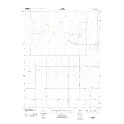
2012 Map of Logan SW
USGS Topo · Published 2012About this map
Bow Cr defines the drainage of this rural landscape in Norton County, where the terrain is marked by a persistent grid of section-line roads and intermittent stream beds. The map illustrates a strictly agricultural environment, emphasizing the infrastructure of land division through a network of county roads such as Co Rd-565 and Co Rd-571. For local historians and genealogists, the map identifies key burial sites that anchor the area's pioneer history, specifically Whitfield Cem and Buchanan Brown Cem. These locations offer a tangible link to the families who settled this portion of Kansas, maintaining a presence amidst the vast acreage of the Great Plains long after many original farmsteads have evolved into larger consolidated tracts.
Find a feature on this map
12 named features on this map. Tap any name to fly to it.
Don’t see what you’re looking for? This feature index may not catch every label — zoom into the map to look around manually.
Map Details
Editions of this 2012 Logan SW Map
This is the sole edition of this map. No revisions or reprints were ever made.
Other maps of this area

1893 · Norton
USGS Topo · 1:125,000

1893 · Hill
USGS Topo · 1:125,000

1955 · Beloit
USGS Topo · 1:250,000

1959 · Beloit
USGS Topo · 1:250,000

1969 · Nicodemus
USGS Topo · 1:24,000

1978 · Logan
USGS Topo · 1:24,000

1978 · Edmond
USGS Topo · 1:24,000
1978 · Densmore
USGS Topo · 1:24,000

1978 · Edmond SE
USGS Topo · 1:24,000
1979 · Logan SW
USGS Topo · 1:24,000