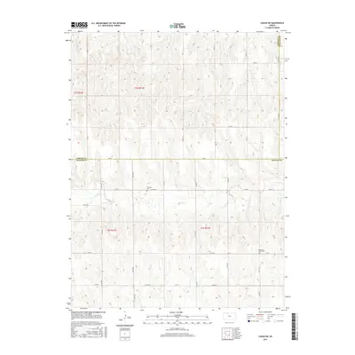
2015 Map of Logan SW
USGS Topo · Published 2015About this map
Bow Cr winds across this rural section of northwest Kansas, carving a gentle valley through the agricultural landscape at the border of Norton and Graham counties. The terrain is defined by a grid of section lines and secondary routes, including the prominent north-south W 1600 Rd and several designated county roads like EE Rd and AA Rd. This 2015 data illustrates the enduring placement of early pioneer landmarks amidst modern farming operations. Genealogists and local historians will find significant value in the location of the Whitfield Cem and Buchanan Brown Cem, which serve as quiet markers of the families who settled this high plains region. The map captures the intersection of three counties—Norton, Graham, and Phillips—revealing how administrative boundaries and natural watercourses shaped the rural development of the area.
Find a feature on this map
32 named features on this map. Tap any name to fly to it.
Don’t see what you’re looking for? This feature index may not catch every label — zoom into the map to look around manually.
Map Details
Editions of this 2015 Logan SW Map
This is the sole edition of this map. No revisions or reprints were ever made.
Other maps of this area

1893 · Norton
USGS Topo · 1:125,000

1893 · Hill
USGS Topo · 1:125,000

1955 · Beloit
USGS Topo · 1:250,000

1959 · Beloit
USGS Topo · 1:250,000

1969 · Nicodemus
USGS Topo · 1:24,000

1978 · Logan
USGS Topo · 1:24,000

1978 · Edmond
USGS Topo · 1:24,000
1978 · Densmore
USGS Topo · 1:24,000

1978 · Edmond SE
USGS Topo · 1:24,000
1979 · Logan SW
USGS Topo · 1:24,000