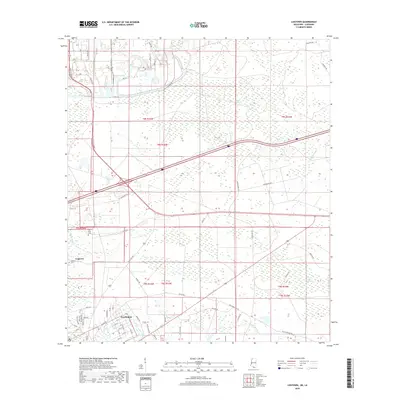
2018 Map of Logtown
USGS Topo · Published 2018About this map
Logtown and Pearlington sit at the center of this coastal Mississippi survey, where the terrestrial landscape gives way to an intricate network of waterways near the Louisiana border. The terrain is defined by the expansive Devils Swamp and Lower Devils Swamp, which are crisscrossed by natural bayous and man-made channels such as S Canal RD. The presence of Logtown Cem and The Point Cem near the riverfront suggests the long-standing human presence in this lowland environment, while the grid of Pearlington shows the local street development including 4th St and 10th Ave. Significant hydrological features like Bogue Homa, Mulatto Bayou, and Bayou Lacroix dominate the eastern and southern portions of the sheet, illustrating the transition from solid ground to the brackish wetlands that characterize the Pearl River basin.
Find a feature on this map
74 named features on this map. Tap any name to fly to it.
Don’t see what you’re looking for? This feature index may not catch every label — zoom into the map to look around manually.
Map Details
Editions of this 2018 Logtown Map
This is the sole edition of this map. No revisions or reprints were ever made.
Other maps of this area

1893 · Rigolets
USGS Topo · 1:62,500

1893 · Toulme
USGS Topo · 1:62,500

1914 · Nicholson
USGS Topo · 1:62,500

1921 · Nicholson
USGS Topo · 1:62,500

1935 · English Lookout
USGS Topo · 1:31,680

1935 · Grand Island Pass
USGS Topo · 1:31,680

1936 · Rigolets
USGS Topo · 1:62,500

1941 · Honey Island
USGS Topo · 1:31,680
1946 · Rigolets
USGS Topo · 1:31,680

1949 · Grand Island Pass
USGS Topo · 1:31,680