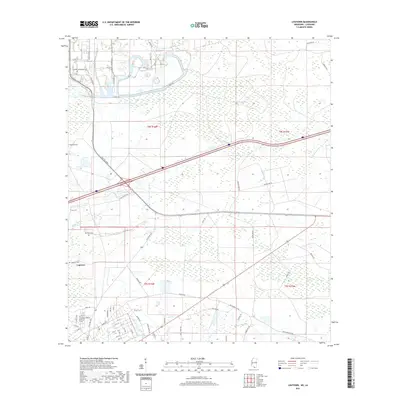
2021 Map of Logtown
USGS Topo · Published 2021About this map
Logtown and its surrounding wetlands define this coastal Hancock County landscape, where the interplay of bayous and swamps dictates the historical pattern of settlement. Local genealogists will find significant value in the distribution of burial grounds across the area, including Logtown Cem, Napoleon Cem, and the uniquely named The Point Cem. The terrain is characterized by intricate water systems such as Devils Swamp, Lower Devils Swamp, and the winding Bogue Homa, which once supported the timber and transport economy of the Pearl River region. Modern infrastructure, represented by Shuttle Pkwy and Propellant Blvd, cuts through the older grid of rural roads and land tracts like Tract 37. This map documents a quiet, water-dominated territory where the legacy of early Mississippi settlements persists alongside the technological footprint of the nearby space center's buffer zones, visible through the bayous like Mulatto Bayou and Pate Bayou.
Find a feature on this map
77 named features on this map. Tap any name to fly to it.
Don’t see what you’re looking for? This feature index may not catch every label — zoom into the map to look around manually.
Map Details
Editions of this 2021 Logtown Map
This is the sole edition of this map. No revisions or reprints were ever made.
Other maps of this area

1893 · Rigolets
USGS Topo · 1:62,500

1893 · Toulme
USGS Topo · 1:62,500

1914 · Nicholson
USGS Topo · 1:62,500

1921 · Nicholson
USGS Topo · 1:62,500

1935 · English Lookout
USGS Topo · 1:31,680

1935 · Grand Island Pass
USGS Topo · 1:31,680

1936 · Rigolets
USGS Topo · 1:62,500

1941 · Honey Island
USGS Topo · 1:31,680
1946 · Rigolets
USGS Topo · 1:31,680

1949 · Grand Island Pass
USGS Topo · 1:31,680