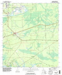
1993 Map of Logtown
USGS Topo · Published 1995About this map
The John C Stennis Space Center (NASA) dominates the northern reaches of this map, representing a significant federal footprint in Hancock County. To the south, the landscape is defined by the winding Pearl River and the expansive, waterlogged terrain of Devils Swamp. The settlement of Logtown is situated near the riverbanks, where the Logtown Cem and The Point Cem provide critical reference points for local genealogy. Farther south, the community of Pearlington anchors the corner of the sheet near Mulatto Bayou. The contrast between the high-tech NASA facility and the traditional riverine settlements highlights the mid-century evolution of the Gulf Coast. Researchers can trace land use patterns from the Waveland Gas Field to the Charles Murphy Sch, as well as numerous Flowing Wells that dot the low-lying coastal plains.
Find a feature on this map
30 named features on this map. Tap any name to fly to it.
Don’t see what you’re looking for? This feature index may not catch every label — zoom into the map to look around manually.
Map Details
Editions of this 1993 Logtown Map
This is the sole edition of this map. No revisions or reprints were ever made.
Other maps of this area

1893 · Rigolets
USGS Topo · 1:62,500

1893 · Toulme
USGS Topo · 1:62,500

1914 · Nicholson
USGS Topo · 1:62,500

1921 · Nicholson
USGS Topo · 1:62,500

1935 · English Lookout
USGS Topo · 1:31,680

1935 · Grand Island Pass
USGS Topo · 1:31,680

1936 · Rigolets
USGS Topo · 1:62,500

1941 · Honey Island
USGS Topo · 1:31,680
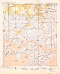
1946 · Rigolets
USGS Topo · 1:31,680

1949 · Grand Island Pass
USGS Topo · 1:31,680