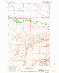
1964 Map of Lohman SE
USGS Topo · Published 1967About this map
Milk River meanders through this portion of Blaine County, providing a stark geographic divide between the northern agricultural plains and the intricate coulee systems to the south. The infrastructure of the mid-1960s is defined by the heavy presence of the Great Northern railroad and the Fort Belknap Canal, which trace the river's path across the valley floor. To the northeast, the outskirts of Chinook are represented by the Chinook Airfield, a Golf Course, and significant local burial sites including Chinook Cem and St Gabriel Cem. Rural life is anchored by the North Yantic Sch and the small settlement of Hazy, while the southern landscape is dominated by the erosion patterns of Threemile Coulee and Black Coulee. The presence of scattered Storage Bins and a Gravel Pit highlights the local reliance on grain storage and land management in this Montana prairie environment.
Find a feature on this map
15 named features on this map. Tap any name to fly to it.
Don’t see what you’re looking for? This feature index may not catch every label — zoom into the map to look around manually.
Map Details
Editions of this 1964 Lohman SE Map
This is the sole edition of this map. No revisions or reprints were ever made.
Other maps of this area

1904 · Yantic
USGS Topo · 1:62,500

1904 · Chinook
USGS Topo · 1:62,500

1912 · Zurich
USGS Topo · 1:125,000

1953 · Havre
USGS Topo · 1:250,000

1956 · Lloyd
USGS Topo · 1:62,500

1956 · Cleveland
USGS Topo · 1:62,500

1957 · Havre
USGS Topo · 1:250,000

1958 · Havre
USGS Topo · 1:250,000

1964 · Rabbit Hills
USGS Topo · 1:24,000

1964 · Telescope Coulee
USGS Topo · 1:24,000