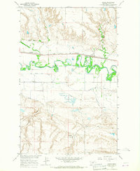
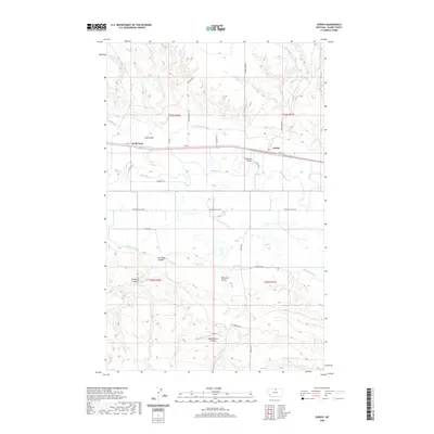
1912 Map of Zurich
USGS Topo · Published 1912About this map
The Great Northern railroad corridor defines the southern landscape of this northern Montana territory, connecting the small settlements of Chinook, Yantic, and Zurich. These rail towns serve as gateways to a vast ranching hinterland stretching north to the United States Canada Boundary Line. The terrain is deeply etched by a complex system of coulees, including Chouteau Coulee and Thibedeau Coulee, which drain toward the winding Milk River. Scattered family operations like Corregan Ranch, Anson Ranch, and Nelsons Ranch illustrate the early 20th-century reliance on seasonal water sources and natural landmarks such as the Rabbit Hills. Local industry is evidenced by Kerrs Coalmine south of the river, while water management for agriculture is visible through the Hay Coulee Reservoir and Cook Reservoir.
Find a feature on this map
41 named features on this map. Tap any name to fly to it.
Don’t see what you’re looking for? This feature index may not catch every label — zoom into the map to look around manually.
Map Details
Editions of this 1912 Zurich Map
This is the sole edition of this map. No revisions or reprints were ever made.
Historical Maps of Chinook Through Time
7 maps found