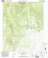
2002 Map of Loma Creston
USGS Topo · Published 2003About this map
The Ojo Del Borrego Grant and surrounding tribal lands define this part of Sandoval County, where complex land boundaries meet a landscape of mesas and deep arroyos. This 2002 revision, based on earlier surveys and updated imagery, illustrates the intersection of the Zia Indian Reservation, Santa Ana Indian Reservation, and Santo Domingo Pueblo Indian Reservation. The terrain is dominated by high-desert features like Santa Ana Mesa and Mesita Cocida, with drainage provided by Arroyo Arenoso and Borrego Canyon. Human presence is marked by scattered Corral sites and the northern reach of the Santa Fe National Forest, while the boundary lines of the Santa Ana Grant show the enduring influence of historic land divisions on modern topographic mapping.
Find a feature on this map
18 named features on this map. Tap any name to fly to it.
Don’t see what you’re looking for? This feature index may not catch every label — zoom into the map to look around manually.
Map Details
Editions of this 2002 Loma Creston Map
This is the sole edition of this map. No revisions or reprints were ever made.
Other maps of this area

1888 · Bernalillo
USGS Topo · 1:125,000

1889 · Albuquerque
USGS Topo · 1:125,000

1890 · Jemes
USGS Topo · 1:125,000

1892 · San Pedro
USGS Topo · 1:125,000

1892 · Jemes
USGS Topo · 1:125,000

1892 · Santa Clara
USGS Topo · 1:125,000

1893 · Albuquerque
USGS Topo · 1:125,000

1943 · Jemez
USGS Topo · 1:62,500

1952 · Jemez
USGS Topo · 1:62,500

1953 · Santo Domingo Pueblo SW
USGS Topo · 1:24,000