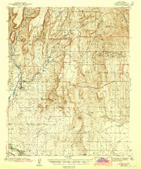
1943 Map of Jemez
USGS Topo · Published 1943About this map
Jemez and the surrounding pueblo lands are shown here in the late 1930s, revealing a landscape defined by ancestral boundaries and early industrial infrastructure. The presence of the Santa Fe Northwestern (RR Abandoned) tracks along the Jemez River signals the transition from active rail commerce to a quieter era. This survey also records the Paliza C C C Camp within the Santa Fe National Forest, marking the era of federal conservation labor in the New Mexico backcountry.
Find a feature on this map
60 named features on this map. Tap any name to fly to it.
Don’t see what you’re looking for? This feature index may not catch every label — zoom into the map to look around manually.
Map Details
Editions of this 1943 Jemez Map
4 editions found
Historical Maps of Jemez Springs Through Time
319 maps found

1890 Jemes
Sandoval County, NM

1892 Jemez
Sandoval County, NM

1939 La Ventana
Sandoval County, NM

1939 San Ysidro
Sandoval County, NM

1943 Jemez
Sandoval County, NM

1943 La Ventana
Sandoval County, NM

1943 San Ysidro
Sandoval County, NM

1952 Frijoles
Sandoval County, NM

1952 Jemez
Sandoval County, NM

1952 Valle Toledo
Sandoval County, NM

1953 Bernalillo NW
Sandoval County, NM

1953 Bland
Sandoval County, NM

1953 Canada
Sandoval County, NM

1953 Cochiti Dam
Sandoval County, NM

1953 Frijoles
Sandoval County, NM

1953 Santo Domingo Pueblo SW
Sandoval County, NM

1954 Hagan
Sandoval County, NM

1954 Loma Machete
Sandoval County, NM

1954 San Felipe Pueblo NE
Sandoval County, NM

1954 Sky Village
Sandoval County, NM

1954 Sky Village SE
Sandoval County, NM

1960 Sky Village NE
Sandoval County, NM

1960 Sky Village NW
Sandoval County, NM

1961 Arroyo Empedrado
Sandoval County, NM

1961 Cabezon Peak
Sandoval County, NM

1961 Casa Salazar
Sandoval County, NM

1961 Cerro Tinaja
Sandoval County, NM

1961 Guadalupe
Sandoval County, NM

1961 Headcut Reservoir
Sandoval County, NM

1961 Johnson Trading Post
Sandoval County, NM

1961 La Gotera
Sandoval County, NM

1961 Mesa Portales
Sandoval County, NM

1961 Puerco Dam
Sandoval County, NM

1961 Wolf Stand
Sandoval County, NM

1963 Arroyo Chijuillita
Sandoval County, NM

1963 Five Lakes Canyon NE
Sandoval County, NM

1963 Five Lakes Canyon NW
Sandoval County, NM

1963 Taylor Ranch
Sandoval County, NM

1966 Counselor
Sandoval County, NM

1966 Deer Mesa
Sandoval County, NM

1966 Lybrook SE
Sandoval County, NM

1966 Mule Dam
Sandoval County, NM

1966 Tancosa Windmill
Sandoval County, NM

1969 Holy Ghost Spring
Sandoval County, NM

1969 Ojito Spring
Sandoval County, NM

1969 San Ysidro
Sandoval County, NM

1970 Bear Springs Peak
Sandoval County, NM

1970 Gilman
Sandoval County, NM

1970 La Ventana
Sandoval County, NM

1970 Loma Creston
Sandoval County, NM

1970 Rancho Del Chaparral
Sandoval County, NM

1970 Redondo Peak
Sandoval County, NM

1970 San Miguel Mountain
Sandoval County, NM

1970 San Pablo
Sandoval County, NM

1970 Seven Springs
Sandoval County, NM

1970 Valle San Antonio
Sandoval County, NM

1975 Hagan
Sandoval County, NM

1984 Frijoles
Sandoval County, NM

1990 Arroyo De Las Calabacillas
Sandoval County, NM

1990 Bernalillo NW
Sandoval County, NM

1990 Hagan
Sandoval County, NM

1990 Loma Machete
Sandoval County, NM

1990 San Felipe Mesa
Sandoval County, NM

1990 San Felipe Pueblo NE
Sandoval County, NM

1995 Cerro Tinaja
Sandoval County, NM

1995 Guadalupe
Sandoval County, NM

2002 Arroyo Chijuillita
Sandoval County, NM

2002 Bear Springs Peak
Sandoval County, NM

2002 Bland
Sandoval County, NM

2002 Canada
Sandoval County, NM

2002 Cochiti Dam
Sandoval County, NM

2002 Frijoles
Sandoval County, NM

2002 Gilman
Sandoval County, NM

2002 La Ventana
Sandoval County, NM

2002 Loma Creston
Sandoval County, NM

2002 Mesa Portales
Sandoval County, NM

2002 Rancho Del Chaparral
Sandoval County, NM

2002 Redondo Peak
Sandoval County, NM

2002 San Miguel Mountain
Sandoval County, NM

2002 San Pablo
Sandoval County, NM

2002 Seven Springs
Sandoval County, NM

2002 Valle San Antonio
Sandoval County, NM

2002 Valle Toledo
Sandoval County, NM

2006 Hagan
Sandoval County, NM

2010 Arroyo de las Calabacillas
Sandoval County, NM

2010 Arroyo Empedrado
Sandoval County, NM

2010 Bernalillo NW
Sandoval County, NM

2010 Cabezon Peak
Sandoval County, NM

2010 Casa Salazar
Sandoval County, NM

2010 Cerro Conejo
Sandoval County, NM

2010 Collier Draw
Sandoval County, NM

2010 Counselor
Sandoval County, NM

2010 Deer Mesa
Sandoval County, NM

2010 Five Lakes Canyon NE
Sandoval County, NM

2010 Five Lakes Canyon NW
Sandoval County, NM

2010 Headcut Reservoir
Sandoval County, NM

2010 Holy Ghost Spring
Sandoval County, NM

2010 Johnson Trading Post
Sandoval County, NM

2010 La Gotera
Sandoval County, NM

2010 Loma Machete
Sandoval County, NM

2010 Lybrook SE
Sandoval County, NM

2010 Mule Dam
Sandoval County, NM

2010 Ojito Spring
Sandoval County, NM

2010 Puerco Dam
Sandoval County, NM

2010 San Felipe Mesa
Sandoval County, NM

2010 San Felipe Pueblo NE
Sandoval County, NM

2010 Santo Domingo Pueblo SW
Sandoval County, NM

2010 San Ysidro
Sandoval County, NM

2010 Tancosa Windmill
Sandoval County, NM

2010 Taylor Ranch
Sandoval County, NM

2010 Wolf Stand
Sandoval County, NM

2011 Arroyo Chijuillita
Sandoval County, NM

2011 Bear Springs Peak
Sandoval County, NM

2011 Bland
Sandoval County, NM

2011 Canada
Sandoval County, NM

2011 Cerro Tinaja
Sandoval County, NM

2011 Cochiti Dam
Sandoval County, NM

2011 Frijoles
Sandoval County, NM

2011 Gilman
Sandoval County, NM

2011 Guadalupe
Sandoval County, NM

2011 Hagan
Sandoval County, NM

2011 La Ventana
Sandoval County, NM

2011 Loma Creston
Sandoval County, NM

2011 Mesa Portales
Sandoval County, NM

2011 Rancho del Chaparral
Sandoval County, NM

2011 Redondo Peak
Sandoval County, NM

2011 San Miguel Mountain
Sandoval County, NM

2011 San Pablo
Sandoval County, NM

2011 Seven Springs
Sandoval County, NM

2011 Valle San Antonio
Sandoval County, NM

2011 Valle Toledo
Sandoval County, NM

2013 Arroyo Chijuillita
Sandoval County, NM

2013 Arroyo de las Calabacillas
Sandoval County, NM

2013 Arroyo Empedrado
Sandoval County, NM

2013 Bear Springs Peak
Sandoval County, NM

2013 Bernalillo NW
Sandoval County, NM

2013 Bland
Sandoval County, NM

2013 Cabezon Peak
Sandoval County, NM

2013 Canada
Sandoval County, NM

2013 Casa Salazar
Sandoval County, NM

2013 Cerro Conejo
Sandoval County, NM

2013 Cerro Tinaja
Sandoval County, NM

2013 Cochiti Dam
Sandoval County, NM

2013 Collier Draw
Sandoval County, NM

2013 Counselor
Sandoval County, NM

2013 Deer Mesa
Sandoval County, NM

2013 Five Lakes Canyon NE
Sandoval County, NM

2013 Five Lakes Canyon NW
Sandoval County, NM

2013 Frijoles
Sandoval County, NM

2013 Gilman
Sandoval County, NM

2013 Guadalupe
Sandoval County, NM

2013 Hagan
Sandoval County, NM

2013 Headcut Reservoir
Sandoval County, NM

2013 Holy Ghost Spring
Sandoval County, NM

2013 Johnson Trading Post
Sandoval County, NM

2013 La Gotera
Sandoval County, NM

2013 La Ventana
Sandoval County, NM

2013 Loma Creston
Sandoval County, NM

2013 Loma Machete
Sandoval County, NM

2013 Lybrook SE
Sandoval County, NM

2013 Mesa Portales
Sandoval County, NM

2013 Mule Dam
Sandoval County, NM

2013 Ojito Spring
Sandoval County, NM

2013 Puerco Dam
Sandoval County, NM

2013 Rancho del Chaparral
Sandoval County, NM

2013 Redondo Peak
Sandoval County, NM

2013 San Felipe Mesa
Sandoval County, NM

2013 San Felipe Pueblo NE
Sandoval County, NM

2013 San Miguel Mountain
Sandoval County, NM

2013 San Pablo
Sandoval County, NM

2013 Santo Domingo Pueblo SW
Sandoval County, NM

2013 San Ysidro
Sandoval County, NM

2013 Seven Springs
Sandoval County, NM

2013 Tancosa Windmill
Sandoval County, NM

2013 Taylor Ranch
Sandoval County, NM

2013 Valle San Antonio
Sandoval County, NM

2013 Valle Toledo
Sandoval County, NM

2013 Wolf Stand
Sandoval County, NM

2017 Arroyo Chijuillita
Sandoval County, NM

2017 Arroyo de las Calabacillas
Sandoval County, NM

2017 Arroyo Empedrado
Sandoval County, NM

2017 Bear Springs Peak
Sandoval County, NM

2017 Bernalillo NW
Sandoval County, NM

2017 Bland
Sandoval County, NM

2017 Cabezon Peak
Sandoval County, NM

2017 Canada
Sandoval County, NM

2017 Casa Salazar
Sandoval County, NM

2017 Cerro Conejo
Sandoval County, NM

2017 Cerro Tinaja
Sandoval County, NM

2017 Cochiti Dam
Sandoval County, NM

2017 Collier Draw
Sandoval County, NM

2017 Counselor
Sandoval County, NM

2017 Deer Mesa
Sandoval County, NM

2017 Five Lakes Canyon NE
Sandoval County, NM

2017 Five Lakes Canyon NW
Sandoval County, NM

2017 Frijoles
Sandoval County, NM

2017 Gilman
Sandoval County, NM

2017 Guadalupe
Sandoval County, NM

2017 Hagan
Sandoval County, NM

2017 Headcut Reservoir
Sandoval County, NM

2017 Holy Ghost Spring
Sandoval County, NM

2017 Johnson Trading Post
Sandoval County, NM

2017 La Gotera
Sandoval County, NM

2017 La Ventana
Sandoval County, NM

2017 Loma Creston
Sandoval County, NM

2017 Loma Machete
Sandoval County, NM

2017 Lybrook SE
Sandoval County, NM

2017 Mesa Portales
Sandoval County, NM

2017 Mule Dam
Sandoval County, NM

2017 Ojito Spring
Sandoval County, NM

2017 Puerco Dam
Sandoval County, NM

2017 Rancho del Chaparral
Sandoval County, NM

2017 Redondo Peak
Sandoval County, NM

2017 San Felipe Mesa
Sandoval County, NM

2017 San Felipe Pueblo NE
Sandoval County, NM

2017 San Miguel Mountain
Sandoval County, NM

2017 San Pablo
Sandoval County, NM

2017 Santo Domingo Pueblo SW
Sandoval County, NM

2017 San Ysidro
Sandoval County, NM

2017 Seven Springs
Sandoval County, NM

2017 Tancosa Windmill
Sandoval County, NM

2017 Taylor Ranch
Sandoval County, NM

2017 Valle San Antonio
Sandoval County, NM

2017 Valle Toledo
Sandoval County, NM

2017 Wolf Stand
Sandoval County, NM

2020 Arroyo Chijuillita
Sandoval County, NM

2020 Arroyo de las Calabacillas
Sandoval County, NM

2020 Arroyo Empedrado
Sandoval County, NM

2020 Bear Springs Peak
Sandoval County, NM

2020 Bernalillo NW
Sandoval County, NM

2020 Bland
Sandoval County, NM

2020 Cabezon Peak
Sandoval County, NM

2020 Canada
Sandoval County, NM

2020 Casa Salazar
Sandoval County, NM

2020 Cerro Conejo
Sandoval County, NM

2020 Cerro Tinaja
Sandoval County, NM

2020 Cochiti Dam
Sandoval County, NM

2020 Collier Draw
Sandoval County, NM

2020 Counselor
Sandoval County, NM

2020 Deer Mesa
Sandoval County, NM

2020 Five Lakes Canyon NE
Sandoval County, NM

2020 Five Lakes Canyon NW
Sandoval County, NM

2020 Frijoles
Sandoval County, NM

2020 Gilman
Sandoval County, NM

2020 Guadalupe
Sandoval County, NM

2020 Hagan
Sandoval County, NM

2020 Headcut Reservoir
Sandoval County, NM

2020 Holy Ghost Spring
Sandoval County, NM

2020 Johnson Trading Post
Sandoval County, NM

2020 La Gotera
Sandoval County, NM

2020 La Ventana
Sandoval County, NM

2020 Loma Creston
Sandoval County, NM

2020 Loma Machete
Sandoval County, NM

2020 Lybrook SE
Sandoval County, NM

2020 Mesa Portales
Sandoval County, NM

2020 Mule Dam
Sandoval County, NM

2020 Ojito Spring
Sandoval County, NM

2020 Puerco Dam
Sandoval County, NM

2020 Rancho del Chaparral
Sandoval County, NM

2020 Redondo Peak
Sandoval County, NM

2020 San Felipe Mesa
Sandoval County, NM

2020 San Felipe Pueblo NE
Sandoval County, NM

2020 San Miguel Mountain
Sandoval County, NM

2020 San Pablo
Sandoval County, NM

2020 Santo Domingo Pueblo SW
Sandoval County, NM

2020 San Ysidro
Sandoval County, NM

2020 Seven Springs
Sandoval County, NM

2020 Tancosa Windmill
Sandoval County, NM

2020 Taylor Ranch
Sandoval County, NM

2020 Valle San Antonio
Sandoval County, NM

2020 Valle Toledo
Sandoval County, NM

2020 Wolf Stand
Sandoval County, NM

2023 Arroyo Chijuillita
Sandoval County, NM

2023 Arroyo de las Calabacillas
Sandoval County, NM

2023 Arroyo Empedrado
Sandoval County, NM

2023 Bear Springs Peak
Sandoval County, NM

2023 Bernalillo NW
Sandoval County, NM

2023 Bland
Sandoval County, NM

2023 Cabezon Peak
Sandoval County, NM

2023 Canada
Sandoval County, NM

2023 Casa Salazar
Sandoval County, NM

2023 Cerro Conejo
Sandoval County, NM

2023 Cerro Tinaja
Sandoval County, NM

2023 Cochiti Dam
Sandoval County, NM

2023 Collier Draw
Sandoval County, NM

2023 Counselor
Sandoval County, NM

2023 Deer Mesa
Sandoval County, NM

2023 Five Lakes Canyon NE
Sandoval County, NM

2023 Five Lakes Canyon NW
Sandoval County, NM

2023 Frijoles
Sandoval County, NM

2023 Gilman
Sandoval County, NM

2023 Guadalupe
Sandoval County, NM

2023 Hagan
Sandoval County, NM

2023 Headcut Reservoir
Sandoval County, NM

2023 Holy Ghost Spring
Sandoval County, NM

2023 Johnson Trading Post
Sandoval County, NM

2023 La Gotera
Sandoval County, NM

2023 La Ventana
Sandoval County, NM

2023 Loma Creston
Sandoval County, NM

2023 Loma Machete
Sandoval County, NM

2023 Lybrook SE
Sandoval County, NM

2023 Mesa Portales
Sandoval County, NM

2023 Mule Dam
Sandoval County, NM

2023 Ojito Spring
Sandoval County, NM

2023 Puerco Dam
Sandoval County, NM

2023 Rancho del Chaparral
Sandoval County, NM

2023 Redondo Peak
Sandoval County, NM

2023 San Felipe Mesa
Sandoval County, NM

2023 San Felipe Pueblo NE
Sandoval County, NM

2023 San Miguel Mountain
Sandoval County, NM

2023 San Pablo
Sandoval County, NM

2023 Santo Domingo Pueblo SW
Sandoval County, NM

2023 San Ysidro
Sandoval County, NM

2023 Seven Springs
Sandoval County, NM

2023 Tancosa Windmill
Sandoval County, NM

2023 Taylor Ranch
Sandoval County, NM

2023 Valle San Antonio
Sandoval County, NM

2023 Valle Toledo
Sandoval County, NM

2023 Wolf Stand
Sandoval County, NM