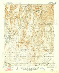
1943 Map of Jemez
USGS Topo · Published 1948About this map
Jemez Pueblo and the Sia Pueblo anchor this high-desert landscape, where deep canyons like San Diego Canyon and Virgin Canyon carve through the mesas of the Santa Fe National Forest. The map records a complex overlay of land history, from numerous unidentified Ruins dotting San Juan Mesa to the industrial presence of the Spanish Queen Mine. In the northern reaches, the Paliza CCC Camp sits along the Rio Vallecitos, a reminder of New Deal-era infrastructure within the canyon systems. Transport is defined by the canyon floors, following the Jemez River and the route of the Northwestern Pacific RR (Abandoned), which once connected these isolated settlements. Settlements such as Lower Vallecitos and the village of Jemez provide critical points of reference for genealogists and historians tracing the settlement patterns of Sandoval County during the late 1930s.
Find a feature on this map
61 named features on this map. Tap any name to fly to it.
Don’t see what you’re looking for? This feature index may not catch every label — zoom into the map to look around manually.
Map Details
Editions of this 1943 Jemez Map
4 editions found

Other maps of this area

1888 · Bernalillo
USGS Topo · 1:125,000

1889 · Albuquerque
USGS Topo · 1:125,000

1890 · Jemes
USGS Topo · 1:125,000

1892 · San Pedro
USGS Topo · 1:125,000

1892 · Jemes
USGS Topo · 1:125,000

1892 · Santa Clara
USGS Topo · 1:125,000

1893 · Albuquerque
USGS Topo · 1:125,000

1937 · Jemez Springs
USGS Topo · 1:48,000

1939 · La Ventana
USGS Topo · 1:62,500

1939 · San Ysidro
USGS Topo · 1:62,500