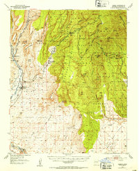
1943 Map of Jemez
USGS Topo · Published 1953About this map
Jemez (Jemez Pueblo P O) sits at the confluence of the Jemez River and Vallecito Creek, serving as a central hub for the surrounding grant lands in the mid-20th century. The landscape is defined by massive plateau features like the Mesa de Guadalupe and Meseta Blanca, intersected by deep canyons such as Virgin Canyon and Cañon de San Diego. This survey captures the region's diverse economic and social activity, from the Spanish Queen Mine and various Pumice Mines to the Elsa Seligman Girl Scout Camp. Cultural and ancestral boundaries are heavily represented through numerous land grants, including the San Jose De Grant, San Juan Grant, and Zia Pueblo Grant. Transportation through the high country is marked by the Bland Bear Springs Trail, while the lower elevations show the development of Lower Vallecitos (Ponderosa P O) near the Arroyo Chamisa.
Find a feature on this map
61 named features on this map. Tap any name to fly to it.
Don’t see what you’re looking for? This feature index may not catch every label — zoom into the map to look around manually.
Map Details
Editions of this 1943 Jemez Map
4 editions found

Other maps of this area

1888 · Bernalillo
USGS Topo · 1:125,000

1889 · Albuquerque
USGS Topo · 1:125,000

1890 · Jemes
USGS Topo · 1:125,000

1892 · San Pedro
USGS Topo · 1:125,000

1892 · Jemes
USGS Topo · 1:125,000

1892 · Santa Clara
USGS Topo · 1:125,000

1893 · Albuquerque
USGS Topo · 1:125,000

1937 · Jemez Springs
USGS Topo · 1:48,000

1939 · La Ventana
USGS Topo · 1:62,500

1939 · San Ysidro
USGS Topo · 1:62,500