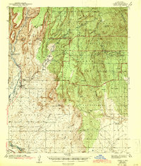
1943 Map of Jemez
USGS Topo · Published 1943About this map
Jemez and its surrounding pueblo lands serve as the anchor for this 1940s landscape, where the Jemez River carves through a region defined by high mesas and deep canyons. The transition from industrial utility to conservation is visible in the abandoned rail corridors of the Santa Fe Northwestern RR and the Sia RR, which once serviced the timber and mining interests of the area.
Find a feature on this map
47 named features on this map. Tap any name to fly to it.
Don’t see what you’re looking for? This feature index may not catch every label — zoom into the map to look around manually.
Map Details
Editions of this 1943 Jemez Map
4 editions found

Other maps of this area

1888 · Bernalillo
USGS Topo · 1:125,000

1889 · Albuquerque
USGS Topo · 1:125,000

1890 · Jemes
USGS Topo · 1:125,000

1892 · San Pedro
USGS Topo · 1:125,000

1892 · Jemes
USGS Topo · 1:125,000

1892 · Santa Clara
USGS Topo · 1:125,000

1893 · Albuquerque
USGS Topo · 1:125,000

1937 · Jemez Springs
USGS Topo · 1:48,000

1939 · La Ventana
USGS Topo · 1:62,500

1939 · San Ysidro
USGS Topo · 1:62,500