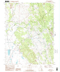
1995 Map of Loma Rica
USGS Topo · Published 1995About this map
Loma Rica serves as the central hub of this Northern California landscape during the mid-1990s, where the foothills of the Sierra Nevada meet the valley floor. The map documents an intricate network of water management features, including the Loma Rica Browns Valley Ditch, Mahle Ditch, and Siphon Ditch, illustrating the area's historical reliance on gravity-fed irrigation for agriculture and mining operations. This hydraulic infrastructure crisscrosses the terrain near Browns Valley Ridge, connecting seasonal streams like Honcut Creek and Tennessee Creek.
Find a feature on this map
30 named features on this map. Tap any name to fly to it.
Don’t see what you’re looking for? This feature index may not catch every label — zoom into the map to look around manually.
Map Details
Editions of this 1995 Loma Rica Map
This is the sole edition of this map. No revisions or reprints were ever made.
Other maps of this area

1888 · Marysville
USGS Topo · 1:125,000

1888 · Smartsville
USGS Topo · 1:125,000

1891 · Marysville
USGS Topo · 1:125,000

1891 · Smartsville
USGS Topo · 1:125,000

1892 · Smartsville
USGS Topo · 1:125,000

1894 · Smartsville
USGS Topo · 1:125,000

1894 · Marysville
USGS Topo · 1:125,000

1895 · Marysville
USGS Topo · 1:125,000

1895 · Smartsville
USGS Topo · 1:125,000

1911 · Browns Valley
USGS Topo · 1:31,680