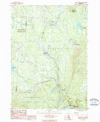
1986 Map of Londonderry
USGS Topo · Published 1987About this map
The West River carves a deep valley through this Windham County landscape, serving as the primary corridor for settlements like Londonderry and South Londonderry. During the mid-1980s, these villages remained hubs of local activity, surrounded by the protected expanses of the Green Mountain National Forest and Ball Mtn State Park. The map reveals a high concentration of recreational and conservation lands, including Lowell Lake State Park and the waters of Gale Meadows Pond.
Find a feature on this map
36 named features on this map. Tap any name to fly to it.
Don’t see what you’re looking for? This feature index may not catch every label — zoom into the map to look around manually.
Map Details
Editions of this 1986 Londonderry Map
This is the sole edition of this map. No revisions or reprints were ever made.
Other maps of this area

1893 · Wallingford
USGS Topo · 1:62,500

1894 · Londonderry
USGS Topo · 1:62,500

1899 · Londonderry
USGS Topo · 1:62,500

1928 · Ludlow
USGS Topo · 1:48,000

1929 · Ludlow
USGS Topo · 1:62,500

1930 · Saxtons River
USGS Topo · 1:48,000

1932 · Ludlow
USGS Topo · 1:62,500

1933 · Saxtons River
USGS Topo · 1:62,500

1950 · Glens Falls
USGS Topo · 1:250,000

1955 · Wallingford
USGS Topo · 1:62,500