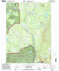
1997 Map of Londonderry
USGS Topo · Published 2000About this map
West River carves a deep valley through this corner of the Green Mountains, anchoring the development of Londonderry and South Londonderry. By the late twentieth century, the landscape reflected a transition from traditional mountain agriculture to a recreation-based economy, evidenced by the Magic Mountain/Winter Sports Area and Viking Cross Country Ski Area. The rugged terrain is managed through several large public tracts, including the Green Mountain National Forest and Ball Mountain State Park, which surrounds the massive Ball Mountain Dam. Genealogists will find a wealth of local history preserved in numerous small family and community burial grounds such as Brooks Cem, Collins Cem, and the remote West Windham Cem. The map also traces the legacy of local industry through several gravel pits and the path of the Winhall River meeting the primary river valley.
Find a feature on this map
49 named features on this map. Tap any name to fly to it.
Don’t see what you’re looking for? This feature index may not catch every label — zoom into the map to look around manually.
Map Details
Editions of this 1997 Londonderry Map
This is the sole edition of this map. No revisions or reprints were ever made.
Other maps of this area

1893 · Wallingford
USGS Topo · 1:62,500

1894 · Londonderry
USGS Topo · 1:62,500

1899 · Londonderry
USGS Topo · 1:62,500

1928 · Ludlow
USGS Topo · 1:48,000

1929 · Ludlow
USGS Topo · 1:62,500

1930 · Saxtons River
USGS Topo · 1:48,000

1932 · Ludlow
USGS Topo · 1:62,500

1933 · Saxtons River
USGS Topo · 1:62,500

1950 · Glens Falls
USGS Topo · 1:250,000

1955 · Wallingford
USGS Topo · 1:62,500