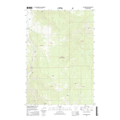
2017 Map of Lone Indian Peak
USGS Topo · Published 2017About this map
Gallatin National Forest dominates this high-altitude landscape where the Gallatin River carves a path alongside Gallatin Rd. Small settlements like Red Cliff and Lemondrop provide human context to a region defined by dramatic elevation changes and a sequence of tributary creeks including First Cr and Fourth Cr. The transportation network is built around river crossings, with Lemon Bridge and Red Cliff Bridge serving as vital links. High ridges and peaks dictate the drainage patterns of the area, from Eaglehead Mtn in the northeast to the namesake Lone Indian Peak in the south. The placement of landmarks like Prohibition Rock and Blizzard Ridge suggests a landscape shaped by extreme weather and local lore, while the secluded Golden Trout Lakes highlight the undisturbed character of the high backcountry.
Find a feature on this map
35 named features on this map. Tap any name to fly to it.
Don’t see what you’re looking for? This feature index may not catch every label — zoom into the map to look around manually.
Map Details
Editions of this 2017 Lone Indian Peak Map
This is the sole edition of this map. No revisions or reprints were ever made.
Other maps of this area

1888 · Three Forks
USGS Topo · 1:250,000

1894 · Three Forks
USGS Topo · 1:250,000

1895 · Three Forks
USGS Topo · 1:250,000

1947 · Bozeman
USGS Topo · 1:250,000

1948 · Bozeman
USGS Topo · 1:250,000

1950 · Spanish Peaks
USGS Topo · 1:62,500

1950 · Sphinx Mountain
USGS Topo · 1:62,500

1955 · Bozeman
USGS Topo · 1:250,000

1955 · Garnet Mountain
USGS Topo · 1:62,500

1955 · Crown Butte
USGS Topo · 1:62,500