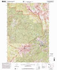
1997 Map of Lone Mountain
USGS Topo · Published 2002About this map
Lone Mountain dominates the southern landscape of this 1990s Madison County survey, where the burgeoning infrastructure of Big Sky Mountain Village meets the high-altitude wilderness. The map details the transition from the recreational development of the Big Sky Ski Area, marked by numerous ski lift lines and Lake Levinsky, into the protected reaches of the Lee Metcalf Wilderness. A network of glacial water bodies, including the Spanish Lakes, Ulerys Lakes, and Shadow Lake, are tucked into the high basins formed by Blaze Mountain and the Beehive Basin. The hydrology is defined by the headwaters of the Middle Fork Gallatin River and Jack Creek, which drain the eastern and western slopes of the central ridge. This period shows the established footprint of mountain tourism alongside the preserved boundaries of the Beaverhead National Forest.
Find a feature on this map
38 named features on this map. Tap any name to fly to it.
Don’t see what you’re looking for? This feature index may not catch every label — zoom into the map to look around manually.
Map Details
Editions of this 1997 Lone Mountain Map
This is the sole edition of this map. No revisions or reprints were ever made.
Other maps of this area

1888 · Three Forks
USGS Topo · 1:250,000

1894 · Three Forks
USGS Topo · 1:250,000

1895 · Three Forks
USGS Topo · 1:250,000

1947 · Bozeman
USGS Topo · 1:250,000

1948 · Bozeman
USGS Topo · 1:250,000

1949 · Ennis
USGS Topo · 1:62,500

1950 · Cameron
USGS Topo · 1:62,500

1950 · Spanish Peaks
USGS Topo · 1:62,500

1950 · Sphinx Mountain
USGS Topo · 1:62,500

1955 · Bozeman
USGS Topo · 1:250,000