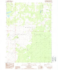
1988 Map of Lone Pine Butte
USGS Topo · Published 1988About this map
Lone Pine Butte serves as a central landmark within the high-desert landscape of the Modoc National Forest in this late-1980s topographic record. The map reveals a land defined by water management and natural springs, crucial for land use in this part of California. From the northern reaches of Lone Pine Lake to the scattered locations of Badger Well and other nameless wells, the survey documents the sparse but vital infrastructure of the era. The presence of Dalton Reservoir and the drainage of Mowitz Creek suggests a territory geared toward resource management and grazing. This provisional survey provides researchers with a detailed view of the terrain before later digital transitions, marking the exact placement of tanks and springs like Davis Spring that were essential to local life and forest service operations.
Find a feature on this map
12 named features on this map. Tap any name to fly to it.
Don’t see what you’re looking for? This feature index may not catch every label — zoom into the map to look around manually.
Map Details
Editions of this 1988 Lone Pine Butte Map
This is the sole edition of this map. No revisions or reprints were ever made.
Other maps of this area

1886 · Alturas
USGS Topo · 1:250,000

1886 · Modoc Lava Bed
USGS Topo · 1:250,000

1892 · Modoc Lava-Bed
USGS Topo · 1:250,000

1892 · Alturas
USGS Topo · 1:250,000

1951 · Clear Lake Reservoir
USGS Topo · 1:62,500

1952 · Hackamore
USGS Topo · 1:62,500

1954 · Alturas
USGS Topo · 1:250,000

1958 · Alturas
USGS Topo · 1:250,000

1962 · Alturas
USGS Topo · 1:250,000

1962 · Steele Swamp
USGS Topo · 1:62,500