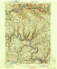
1923 Map of Long Eddy
USGS Topo · Published 1939About this map
East Branch Delaware River and the Delaware River carve a winding course through the borderlands of New York and Pennsylvania, defining the geography of the 1920s. The settlement at Long Eddy serves as a focal point where the river meets the Erie Railroad, a lifeline for the rural communities of the Upper Delaware Valley. The terrain is marked by numerous family-named hollows and ridges, such as Jehu Mtn and Cherry Ridge, which shaped the placement of isolated schools like Tyler Wood School and Gould School.
Find a feature on this map
139 named features on this map. Tap any name to fly to it.
Don’t see what you’re looking for? This feature index may not catch every label — zoom into the map to look around manually.
Map Details
Editions of this 1923 Long Eddy Map
5 editions found
Other maps of this area

1892 · Honesdale
USGS Topo · 1:62,500

1920 · Long Eddy
USGS Topo · 1:62,500

1920 · Damascus
USGS Topo · 1:62,500

1921 · Long Eddy
USGS Topo · 1:48,000

1921 · Livingston Manor
USGS Topo · 1:62,500

1922 · White Lake
USGS Topo · 1:62,500

1922 · Andes
USGS Topo · 1:62,500

1923 · Damascus
USGS Topo · 1:62,500

1923 · Long Eddy
USGS Topo · 1:62,500

1923 · Walton
USGS Topo · 1:48,000