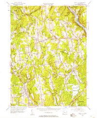
1953 Map of Long Hill
USGS Topo · Published 1958About this map
Monroe and Huntington anchor this Fairfield County landscape during a period of mid-century suburban transition and resource management. The map highlights a sophisticated network of water infrastructure necessary for regional growth, including the sprawling Trap Falls Reservoir, Means Brook Reservoir, and Isinglass Reservoir. These bodies of water sit alongside established agrarian settlements, where family names are preserved in landmarks like Barn Hill, Booth Hill, and the White Hills.
Find a feature on this map
46 named features on this map. Tap any name to fly to it.
Don’t see what you’re looking for? This feature index may not catch every label — zoom into the map to look around manually.
Map Details
Editions of this 1953 Long Hill Map
2 editions found
Other maps of this area

1889 · Derby
USGS Topo · 1:62,500

1891 · Bridgeport
USGS Topo · 1:62,500

1891 · Derby
USGS Topo · 1:62,500

1892 · Danbury
USGS Topo · 1:62,500

1892 · Norwalk
USGS Topo · 1:62,500

1893 · Bridgeport
USGS Topo · 1:62,500

1893 · Norwalk
USGS Topo · 1:62,500

1893 · Derby
USGS Topo · 1:62,500

1915 · Danbury
USGS Topo · 1:62,500

1920 · Bridgeport
USGS Topo · 1:62,500