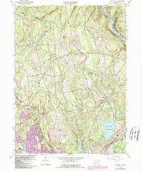
1964 Map of Long Hill
USGS Topo · Published 1985About this map
The Housatonic River serves as the boundary between Fairfield and New Haven counties, carving through a landscape of prominent ridges like Walker Hill and the White Hills. This mid-century survey reflects the mid-1960s suburbanization and infrastructure of towns like Monroe and Trumbull, where new residential patterns began to surround older agricultural landmarks. Notable sites include several historic burial grounds such as Walker Farm Cem and Cutters Farm Cem, along with numerous educational and religious institutions like St Stephens Sch and St Josephs High Sch. The region's water management is dominated by major impoundments, specifically the Trap Falls Reservoir, Isinglass Reservoir, and Means Brook Reservoir. Industrial history is represented by the Tungsten Mine Park and the Conrail rail lines that navigate the valley floors near the Pequonnock River.
Find a feature on this map
63 named features on this map. Tap any name to fly to it.
Don’t see what you’re looking for? This feature index may not catch every label — zoom into the map to look around manually.
Map Details
Editions of this 1964 Long Hill Map
3 editions found
Other maps of this area

1889 · Derby
USGS Topo · 1:62,500

1891 · Bridgeport
USGS Topo · 1:62,500

1891 · Derby
USGS Topo · 1:62,500

1892 · Danbury
USGS Topo · 1:62,500

1892 · Norwalk
USGS Topo · 1:62,500

1893 · Bridgeport
USGS Topo · 1:62,500

1893 · Norwalk
USGS Topo · 1:62,500

1893 · Derby
USGS Topo · 1:62,500

1915 · Danbury
USGS Topo · 1:62,500

1920 · Bridgeport
USGS Topo · 1:62,500