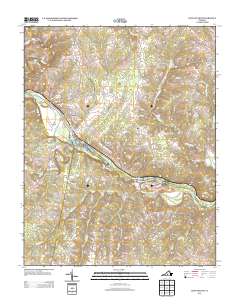
2013 Map of Long Island
USGS Topo · Published 2013About this map
The Roanoke River carves a prominent path through this section of Pittsylvania County, defining the landscape and settlement patterns around Long Island. The river's influence is evident in the naming of local landmarks like Goat Island and the Hale Islands, as well as the historical infrastructure indicated by Collins Ferry Rd and McIver Ferry Rd. These labels point to a time when river crossings were vital nodes for the rural communities of Green Hill and Melrose.
Find a feature on this map
66 named features on this map. Tap any name to fly to it.
Don’t see what you’re looking for? This feature index may not catch every label — zoom into the map to look around manually.
Map Details
Editions of this 2013 Long Island Map
This is the sole edition of this map. No revisions or reprints were ever made.
Other maps of this area

1892 · Lynchburg
USGS Topo · 1:125,000

1892 · Appomattox
USGS Topo · 1:125,000

1947 · Roanoke
USGS Topo · 1:250,000

1953 · Greensboro
USGS Topo · 1:250,000

1954 · Greensboro
USGS Topo · 1:250,000

1954 · Halifax
USGS Topo · 1:62,500

1954 · Riceville
USGS Topo · 1:62,500

1956 · Brookneal
USGS Topo · 1:62,500

1956 · Gladys
USGS Topo · 1:62,500

1959 · Roanoke
USGS Topo · 1:250,000