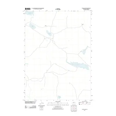
2011 Map of Long Lake
USGS Topo · Published 2011About this map
The Nebraska Sandhills define this landscape in Cherry County, where a series of alkaline lakes and remote ranching outposts characterize the terrain. Long Lake serves as the dominant hydrological feature in the southeast, while South Marsh Lake and Center Lake anchor the northwestern portion of the sheet. This area is sparsely populated, with settlement patterns centered around family operations such as Hassel Ranch and Pederson Ranch. The network of local roads and 4WD tracks suggests a reliance on high-clearance transportation to navigate the sandy hills between isolated water bodies like Twentyone Lake. This survey illustrates the persistent ranching culture of the Great Plains, where large land holdings are dictated by the availability of water and the unique geography of the sand dunes.
Find a feature on this map
6 named features on this map. Tap any name to fly to it.
Don’t see what you’re looking for? This feature index may not catch every label — zoom into the map to look around manually.
Map Details
Editions of this 2011 Long Lake Map
This is the sole edition of this map. No revisions or reprints were ever made.
Other maps of this area

1949 · Long Lake
USGS Topo · 1:62,500

1950 · Simeon
USGS Topo · 1:62,500

1950 · Arabia
USGS Topo · 1:62,500

1951 · Long Lake
USGS Topo · 1:62,500

1951 · Brownlee
USGS Topo · 1:62,500

1957 · Valentine
USGS Topo · 1:250,000

1959 · Valentine
USGS Topo · 1:250,000

1985 · Long Lake
USGS Topo · 1:24,000

1985 · Wilson Valley
USGS Topo · 1:24,000
1985 · Arabia SE
USGS Topo · 1:24,000