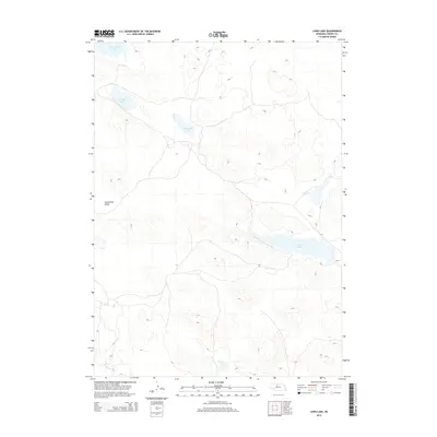
2014 Map of Long Lake
USGS Topo · Published 2014About this map
Sweetwater Valley serves as a prominent landmark in this section of the Nebraska Sandhills, a landscape defined by its distinctive dune formations and interdunal basins. Water is the primary feature of this terrain, with several notable bodies including the expansive Long Lake and the smaller Twentyone Lake. This 2014 survey documents a quiet, sparsely developed region where the land's hydrology dictates the layout of local travel routes and boundaries. The map traces the winding course of Goose Cr and identifies localized water features like South Marsh Lake and Center Lake. For those interested in the natural geography of Cherry County, this map provides an exact look at the relationship between these ephemeral or semi-permanent lakes and the surrounding valley structures during the early 21st century.
Find a feature on this map
6 named features on this map. Tap any name to fly to it.
Don’t see what you’re looking for? This feature index may not catch every label — zoom into the map to look around manually.
Map Details
Editions of this 2014 Long Lake Map
This is the sole edition of this map. No revisions or reprints were ever made.
Other maps of this area

1949 · Long Lake
USGS Topo · 1:62,500

1950 · Simeon
USGS Topo · 1:62,500

1950 · Arabia
USGS Topo · 1:62,500

1951 · Long Lake
USGS Topo · 1:62,500

1951 · Brownlee
USGS Topo · 1:62,500

1957 · Valentine
USGS Topo · 1:250,000

1959 · Valentine
USGS Topo · 1:250,000

1985 · Long Lake
USGS Topo · 1:24,000

1985 · Wilson Valley
USGS Topo · 1:24,000
1985 · Arabia SE
USGS Topo · 1:24,000