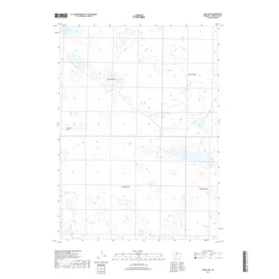
2017 Map of Long Lake
USGS Topo · Published 2017About this map
Sweetwater Valley serves as a prominent landmark in this section of Cherry County, where the hydrology of the Nebraska Sandhills is on full display. The area is defined by a series of significant water bodies, including the elongated Long Lake and the nearby Twentyone Lake. These basins, along with South Marsh Lake and Center Lake further north, illustrate the high water table characteristic of this region. The lack of traditional town centers or dense road networks emphasizes the rural, ranch-oriented land use of the early 21st century. In the southern reaches, the winding path of Goose Cr further defines the drainage patterns of this expansive prairie landscape.
Find a feature on this map
10 named features on this map. Tap any name to fly to it.
Don’t see what you’re looking for? This feature index may not catch every label — zoom into the map to look around manually.
Map Details
Editions of this 2017 Long Lake Map
This is the sole edition of this map. No revisions or reprints were ever made.
Other maps of this area

1949 · Long Lake
USGS Topo · 1:62,500

1950 · Simeon
USGS Topo · 1:62,500

1950 · Arabia
USGS Topo · 1:62,500

1951 · Long Lake
USGS Topo · 1:62,500

1951 · Brownlee
USGS Topo · 1:62,500

1957 · Valentine
USGS Topo · 1:250,000

1959 · Valentine
USGS Topo · 1:250,000

1985 · Long Lake
USGS Topo · 1:24,000

1985 · Wilson Valley
USGS Topo · 1:24,000
1985 · Arabia SE
USGS Topo · 1:24,000