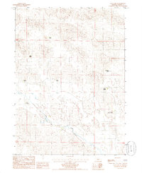
1985 Map of Long Lake SE
USGS Topo · Published 1985About this map
Goose Creek meanders through this section of the Nebraska Sandhills, defining the low-lying drainage of a landscape otherwise dominated by rolling dunes and scattered ranching outposts. Recorded in the mid-1980s, the map document several established family holdings and legacy sites including Piercy Place, Paine Place, and the Hartgraves Place. The distribution of these named locales, alongside active operations like the Ganser Ranch and Gudgel Ranch, illustrates the sparse but persistent settlement pattern of Cherry County. Remote ranching infrastructure is further evidenced by isolated irrigation points such as the Irr Well found near the western boundary. The terrain is marked by traditional land divisions, with section lines and township boundaries like T 28 N T 27 N overlaying the natural topography of the basin.
Find a feature on this map
12 named features on this map. Tap any name to fly to it.
Don’t see what you’re looking for? This feature index may not catch every label — zoom into the map to look around manually.
Map Details
Editions of this 1985 Long Lake SE Map
This is the sole edition of this map. No revisions or reprints were ever made.
Other maps of this area

1949 · Purdum
USGS Topo · 1:62,500

1949 · Koshopah
USGS Topo · 1:62,500

1949 · Long Lake
USGS Topo · 1:62,500

1951 · Long Lake
USGS Topo · 1:62,500

1951 · Purdum
USGS Topo · 1:62,500

1951 · Moon Lake
USGS Topo · 1:62,500

1951 · Koshopah
USGS Topo · 1:62,500

1957 · Valentine
USGS Topo · 1:250,000

1959 · Valentine
USGS Topo · 1:250,000

1985 · Long Lake
USGS Topo · 1:24,000