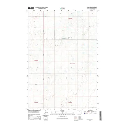
2015 Map of Long Lake SE
USGS Topo · Published 2015About this map
The rolling grasslands of McPherson County are defined by a strict section-line grid and sparse permanent markers. Hoffnungs Gemeinde Cem and the nearby Hoffnungs Cem stand as significant cultural landmarks along 107th St, serving the local community in this rural expanse. The landscape is characterized by numerous small depressions and seasonal wetlands typical of the region's glacial history. In the southern portion of the quadrangle, Foot Cr meanders through the terrain near Plum Rd, representing one of the few named natural drainage features in an area dominated by prairie potholes. This survey provides a clear view of the transportation network, from established routes like 355th Ave to more local tracks such as Oak Rd, illustrating the intersection of modern agriculture and historical land divisions.
Find a feature on this map
23 named features on this map. Tap any name to fly to it.
Don’t see what you’re looking for? This feature index may not catch every label — zoom into the map to look around manually.
Map Details
Editions of this 2015 Long Lake SE Map
This is the sole edition of this map. No revisions or reprints were ever made.
Other maps of this area

1899 · Ellendale
USGS Topo · 1:125,000

1954 · Aberdeen
USGS Topo · 1:250,000

1956 · Aberdeen
USGS Topo · 1:250,000

1968 · Long Lake
USGS Topo · 1:24,000

1968 · Long Lake SE
USGS Topo · 1:24,000

1968 · Long Lake NW
USGS Topo · 1:24,000

1968 · Long Lake NE
USGS Topo · 1:24,000
1968 · Forbes NW
USGS Topo · 1:24,000

1968 · Forbes SW
USGS Topo · 1:24,000

1970 · Leola
USGS Topo · 1:24,000