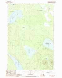
1988 Map of Longley Pond
USGS Topo · Published 1988About this map
Shallow Lake and the surrounding unorganized territories of Piscataquis County appear here in a period of late-twentieth-century forest management. The landscape is defined by its extensive aquatic network, including Longley Pond, Black Pond, and the significant waters of Umbazooksus Lake to the east. A notable terrestrial landmark is the Old Railroad Grade cutting across the northeastern terrain, a remnant of the region's historic logging infrastructure that once moved timber through these remote woods.
Find a feature on this map
19 named features on this map. Tap any name to fly to it.
Don’t see what you’re looking for? This feature index may not catch every label — zoom into the map to look around manually.
Map Details
Editions of this 1988 Longley Pond Map
This is the sole edition of this map. No revisions or reprints were ever made.
Other maps of this area

1954 · Chesuncook
USGS Topo · 1:62,500

1954 · Caucomgomoc Lake
USGS Topo · 1:62,500

1954 · Churchill Lake
USGS Topo · 1:62,500

1954 · Allagash Lake
USGS Topo · 1:62,500

1954 · Presque Isle
USGS Topo · 1:250,000

1958 · Presque Isle
USGS Topo · 1:250,000

1958 · Chesuncook
USGS Topo · 1:62,500

1958 · Caucomgomoc Lake
USGS Topo · 1:62,500

1960 · Presque Isle
USGS Topo · 1:250,000

1961 · Allagash Lake
USGS Topo · 1:62,500