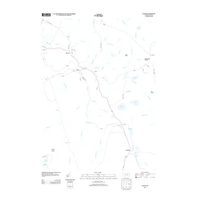
2013 Map of Lopez
USGS Topo · Published 2013About this map
Loyalsock Cr and its numerous tributaries, including Pigeon Cr and Long Run, dominate this section of the Endless Mountains region. The settlement of Lopez serves as a primary waypoint, situated at the junction of Millers Rd and Church St. This 2013 survey illustrates a landscape heavily defined by its water resources and historical timber or mining infrastructure, evidenced by features like Splashdam Pond and Coal Mine Rd. To the south, the village of Ricketts sits near the headwaters of Mehoopany Cr, while northern reaches contain the high ground of Indian Ridge. The map details a network of rural routes such as Turrel Town Rd and Connells Dam Rd, providing access to isolated landmarks like Shumans Lake and Snorting Buck Hollow. This record is essential for understanding the modern footprint of these mountain communities and their relationship with the surrounding game lands.
Find a feature on this map
63 named features on this map. Tap any name to fly to it.
Don’t see what you’re looking for? This feature index may not catch every label — zoom into the map to look around manually.
Map Details
Editions of this 2013 Lopez Map
This is the sole edition of this map. No revisions or reprints were ever made.
Other maps of this area

1891 · Harveys Lake
USGS Topo · 1:62,500

1893 · Harvey Lake
USGS Topo · 1:62,500

1934 · Laporte
USGS Topo · 1:62,500

1943 · Monroeton
USGS Topo · 1:62,500

1945 · Meshoppen
USGS Topo · 1:62,500

1945 · Jenningsville
USGS Topo · 1:24,000

1946 · Dutch Mtn
USGS Topo · 1:24,000

1946 · Sweet Valley
USGS Topo · 1:24,000

1947 · Jenningsville
USGS Topo · 1:31,680
1948 · Dutch Mtn
USGS Topo · 1:24,000
Featured Places
- Colley Township, PA
- Forkston Township, PA
- Laporte Township, PA
- Lopez, Colley Township
- Ricketts, Colley Township