1978 Map of Los Alamos
USGS Topo · Published 1978About this map
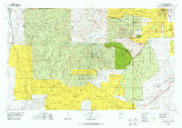
Los Alamos sits at the heart of this complex landscape, positioned on the Pajarito Plateau above the deep incisions of Pueblo Canyon and Los Alamos Canyon. The 1970s terrain is a mosaic of sovereign lands and federal protected areas, where the volcanic peaks of the Jemez Mountains and the Valle San Antonio meet ancient cultural sites. To the south and east, the Rio Grande flows through White Rock Canyon, flanked by the Caja del Rio Plateau. This survey documents a profound layering of history, from the high-altitude geothermal activity at Sulphur Springs to the established agricultural communities along the Santa Cruz River. Numerous indigenous landholdings including the Jemez Indian Reservation and San Ildefonso Indian Reservation are clearly delineated alongside the Bandelier National Monument, illustrating the region's enduring heritage and scientific significance.
Find a feature on this map
144 named features on this map. Tap any name to fly to it.
Don’t see what you’re looking for? This feature index may not catch every label — zoom into the map to look around manually.
Map Details
Editions of this 1978 Los Alamos Map
This is the sole edition of this map. No revisions or reprints were ever made.
Historical Maps of Santa Fe Through Time
1 maps found