
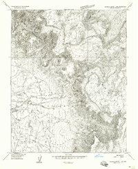
1953 Map of Los Gigantes SE
USGS Topo · Published 1954About this map
Navajo Indian Reservation lands dominate this mid-century topographic study, which captures the complex high-desert landforms of Apache County. The map is defined by the stark verticality of the Mexican Cry area, where dense contour lines illustrate a labyrinth of deep canyons and sheer plateaus. Elevated features such as West Mesa and East Mesa (also labeled E Mesa) rise above the surrounding terrain, serving as primary landmarks in this sparsely populated region. This preliminary edition, compiled from 1950 aerial photography, provides a specialized view of the landscape's natural geometry before later survey refinements, emphasizing the physical isolation and topographic complexity of the Arizona desert.
Find a feature on this map
5 named features on this map. Tap any name to fly to it.
Don’t see what you’re looking for? This feature index may not catch every label — zoom into the map to look around manually.
Map Details
Editions of this 1953 Los Gigantes SE Map
This is the sole edition of this map. No revisions or reprints were ever made.
Other maps of this area

1892 · Canyon De Chelly
USGS Topo · 1:250,000

1953 · Los Gigantes NE
USGS Topo · 1:24,000

1953 · Los Gigantes NW
USGS Topo · 1:24,000

1953 · Redrock Valley SW
USGS Topo · 1:24,000

1953 · Los Gigantes SW
USGS Topo · 1:24,000

1953 · Redrock Valley NW
USGS Topo · 1:24,000

1953 · Los Gigantes Buttes
USGS Topo · 1:62,500

1953 · Redrock Valley
USGS Topo · 1:62,500

1954 · Shiprock
USGS Topo · 1:250,000
1955 · Sonsala Butte 1 NW
USGS Topo · 1:24,000