
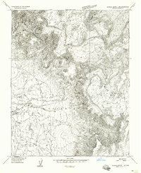
1953 Map of Redrock Valley SW
USGS Topo · Published 1954About this map
The high-altitude topography of the Navajo Indian Reservation dominates this 1950s survey, defined by the towering Lukachukai Mountains and the Chuska Mts. The landscape is a study in verticality, transitioning from the deep drainage of Cove Wash to the steep ridgelines where a Natural Arch stands as a distinct geological marker. Settlement is concentrated near the base of these peaks, centered on the Cove School. A notable logistical feature of the era is the Emergency Landing Strip, situated on a relatively level bench of land amidst the otherwise complex terrain. This map captures the region's infrastructure before modern expansion, showing the network of unimproved roads and isolated structures that serviced this part of Apache County during the early Cold War period.
Find a feature on this map
9 named features on this map. Tap any name to fly to it.
Don’t see what you’re looking for? This feature index may not catch every label — zoom into the map to look around manually.
Map Details
Editions of this 1953 Redrock Valley SW Map
This is the sole edition of this map. No revisions or reprints were ever made.
Other maps of this area

1892 · Canyon De Chelly
USGS Topo · 1:250,000

1953 · Los Gigantes NE
USGS Topo · 1:24,000

1953 · Redrock Valley NE
USGS Topo · 1:24,000

1953 · Redrock Valley SE
USGS Topo · 1:24,000

1953 · Los Gigantes SE
USGS Topo · 1:24,000

1953 · Redrock Valley NW
USGS Topo · 1:24,000

1953 · Los Gigantes Buttes
USGS Topo · 1:62,500

1953 · Redrock Valley
USGS Topo · 1:62,500

1954 · Shiprock
USGS Topo · 1:250,000
1955 · Sonsala Butte 1 NW
USGS Topo · 1:24,000