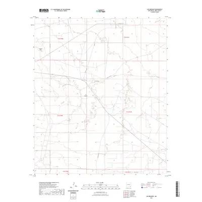
2023 Map of Los Medanos
USGS Topo · Published 2023About this map
Livingston Ridge dominates the northwestern portion of this Eddy County landscape, providing a sharp topographical contrast to the surrounding desert plains. This modern 2023 survey documents the sparse but critical network of roads that service this arid region of southeastern New Mexico. The small settlement of Los Medanos serves as a focal point near the junction of several county and utility routes. The infrastructure is defined by specialized roads like Wipp Rd and Cimarron Rd, which cut across the high desert terrain. Grounded in the Public Land Survey System, the map detail spans multiple townships including t22s r30e and t23s r31e, illustrating how the land has been subdivided for resource management and ranching. Other local pathways such as Mills Ranch Rd and Twin Wells Rd further trace the human footprint across this expansive terrain.
Find a feature on this map
13 named features on this map. Tap any name to fly to it.
Don’t see what you’re looking for? This feature index may not catch every label — zoom into the map to look around manually.
Map Details
Editions of this 2023 Los Medanos Map
This is the sole edition of this map. No revisions or reprints were ever made.
Other maps of this area

1939 · Nash Draw
USGS Topo · 1:62,500

1943 · Nash Draw
USGS Topo · 1:62,500

1954 · Hobbs
USGS Topo · 1:250,000

1958 · Hobbs
USGS Topo · 1:250,000

1963 · Hat Mesa
USGS Topo · 1:62,500
1968 · Pierce Canyon
USGS Topo · 1:24,000
1968 · Big Sinks
USGS Topo · 1:24,000

1973 · Paduca Breaks NW
USGS Topo · 1:24,000

1978 · Jal
USGS Topo · 1:100,000
1984 · Bootleg Ridge
USGS Topo · 1:24,000