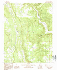
1989 Map of Los Montoyas
USGS Topo · Published 1989About this map
Los Montoyas and San Augustin anchor this late-20th-century landscape in San Miguel County, where the high mesa country meets the river valleys of the Sangre de Cristo foothills. The map reveals a transition between established agricultural settlements and protected lands, such as the Las Vegas Nat Wildlife Refuge in the north. Water management is a primary theme, evidenced by the San Augustin Dam on the Gallinas River and a Gaging Station Gage 6728 that monitors the flow through Apache Canyon. The rugged geography is defined by broad plateaus including Las Vegas Mesa and Apache Mesa, separated by deep drainages like La Cueva Canyon. Small rural clusters like Sheridan and the site of Los Fuertes illustrate the scattered settlement patterns of this high-altitude region, while various Check Dams along Arroyo La Manga show local efforts to control erosion and seasonal runoff.
Find a feature on this map
29 named features on this map. Tap any name to fly to it.
Don’t see what you’re looking for? This feature index may not catch every label — zoom into the map to look around manually.
Map Details
Editions of this 1989 Los Montoyas Map
This is the sole edition of this map. No revisions or reprints were ever made.
Other maps of this area

1889 · Las Vegas
USGS Topo · 1:125,000

1890 · Bernal
USGS Topo · 1:125,000

1891 · Bernal
USGS Topo · 1:125,000

1891 · Las Vegas
USGS Topo · 1:125,000

1893 · Las Vegas
USGS Topo · 1:125,000

1894 · Bernal
USGS Topo · 1:125,000

1954 · Santa Fe
USGS Topo · 1:250,000

1958 · Santa Fe
USGS Topo · 1:250,000

1960 · Villanueva
USGS Topo · 1:62,500

1960 · Apache Springs
USGS Topo · 1:62,500