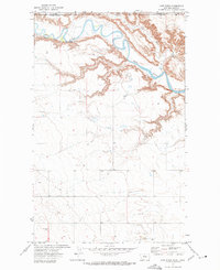
1972 Map of Lost River
USGS Topo · Published 1975About this map
The Milk River meanders across this northern Montana landscape, cutting a deep trench through the undulating plains along the international border. Surveyed in the early 1970s, the terrain shows a sparse but functional infrastructure focused on water management and agricultural storage. The confluence of the Lost River with the larger waterway is a central feature, supported by a Gaging Sta downstream to monitor the river's flow through this arid region. Man-made additions like Storage Bins and an isolated Well suggest a landscape dedicated to dryland ranching or grain production, where water sources and storage points were critical to local survival. This map clearly delineates the administrative intersection of Alberta and Montana, marking the boundary between Medicine Hat District and Hill County.
Find a feature on this map
8 named features on this map. Tap any name to fly to it.
Don’t see what you’re looking for? This feature index may not catch every label — zoom into the map to look around manually.
Map Details
Editions of this 1972 Lost River Map
This is the sole edition of this map. No revisions or reprints were ever made.
Other maps of this area

1919 · Alma
USGS Topo · 1:125,000

1920 · Gildford
USGS Topo · 1:125,000

1943 · Gildford
USGS Topo · 1:125,000

1954 · Shelby
USGS Topo · 1:250,000

1958 · Shelby
USGS Topo · 1:250,000
1972 · Lost River NE
USGS Topo · 1:24,000

1972 · Mc Kinnsey Reservoir East
USGS Topo · 1:24,000

1972 · Mc Kinnsey Reservoir West
USGS Topo · 1:24,000
1972 · Ninemile Coulee West
USGS Topo · 1:24,000
1972 · Goldstone
USGS Topo · 1:24,000