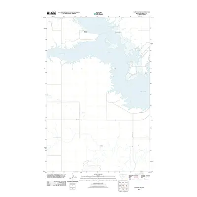
2011 Map of Lothair SW
USGS Topo · Published 2011About this map
Lake Elwell dominates this northern Montana landscape, where the reservoir's complex, branching shoreline cuts deep into the high plains of Liberty County. The terrain is defined by the sharp incisions of glacial coulees, most notably Bishop Coulee and Smith Coulee which reach toward the northern waters, and Timber Coulee to the south. This 2011 survey captures the region's sparse infrastructure, typical of the rural American West, where long stretches of road like Broadhurst Rd and Fas 366 provide the primary transit links across the open country. The contrast between the expansive water of the reservoir and the seasonal drainage patterns of Willow Creek illustrates the significant role of water management and irrigation in this arid environment.
Find a feature on this map
8 named features on this map. Tap any name to fly to it.
Don’t see what you’re looking for? This feature index may not catch every label — zoom into the map to look around manually.
Map Details
Editions of this 2011 Lothair SW Map
This is the sole edition of this map. No revisions or reprints were ever made.
Other maps of this area

1954 · Shelby
USGS Topo · 1:250,000

1958 · Shelby
USGS Topo · 1:250,000

1970 · Carlson Coulee
USGS Topo · 1:24,000

1970 · Knees NE
USGS Topo · 1:24,000

1970 · Uphill Creek
USGS Topo · 1:24,000

1970 · Sagebrush Coulee
USGS Topo · 1:24,000

1970 · Pondera School
USGS Topo · 1:24,000

1970 · Galata
USGS Topo · 1:24,000

1970 · Lothair SW
USGS Topo · 1:24,000
1970 · Lothair
USGS Topo · 1:24,000