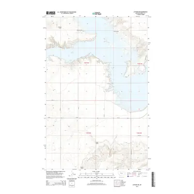
2014 Map of Lothair SW
USGS Topo · Published 2014About this map
Lake Elwell dominates this section of Liberty County, its intricate northern shoreline carved by deep drainage features like Emerson Coulee, Bishop Coulee, and Smith Coulee. These eroded breaks in the plains define the local hydrology, feeding into the reservoir formed by the damming of the Marias River. South of the main body of water, the land transitions to a more regular grid of rural access roads including Pugsley Rd and Broadhurst Rd, which service the agricultural reaches of the Montana High Line. Notable landmarks for local access include Tiber Marina Rd and Island Rd, indicating the area's importance for water-based recreation and infrastructure. Further south, the terrain remains deeply textured with Timber Coulee and Pondera Coulee cutting through the landscape toward the MT-366 corridor.
Find a feature on this map
19 named features on this map. Tap any name to fly to it.
Don’t see what you’re looking for? This feature index may not catch every label — zoom into the map to look around manually.
Map Details
Editions of this 2014 Lothair SW Map
This is the sole edition of this map. No revisions or reprints were ever made.
Other maps of this area

1954 · Shelby
USGS Topo · 1:250,000

1958 · Shelby
USGS Topo · 1:250,000

1970 · Carlson Coulee
USGS Topo · 1:24,000

1970 · Knees NE
USGS Topo · 1:24,000

1970 · Uphill Creek
USGS Topo · 1:24,000

1970 · Sagebrush Coulee
USGS Topo · 1:24,000

1970 · Pondera School
USGS Topo · 1:24,000

1970 · Galata
USGS Topo · 1:24,000

1970 · Lothair SW
USGS Topo · 1:24,000
1970 · Lothair
USGS Topo · 1:24,000