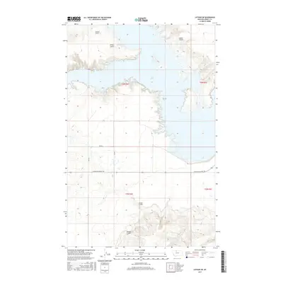
2017 Map of Lothair SW
USGS Topo · Published 2017About this map
Lake Elwell dominates this northern Montana landscape, its irregular shoreline reaching into a series of deep drainages. The terrain is defined by these prominent coulees, including Emerson Coulee and Bishop Coulee to the north, and the southern reaches of Pondera Coulee and Timber Coulee. These features illustrate the erosion patterns characteristic of the high plains where water systems meet the Missouri River's reservoir. Human presence is marked by a grid of rural routes, most notably Mountain Highway 366 crossing the lower third of the quadrangle. The map captures a moment of modern land management within Liberty County, showing the intersection of large-scale water infrastructure and traditional township and range survey lines.
Find a feature on this map
12 named features on this map. Tap any name to fly to it.
Don’t see what you’re looking for? This feature index may not catch every label — zoom into the map to look around manually.
Map Details
Editions of this 2017 Lothair SW Map
This is the sole edition of this map. No revisions or reprints were ever made.
Other maps of this area

1954 · Shelby
USGS Topo · 1:250,000

1958 · Shelby
USGS Topo · 1:250,000

1970 · Carlson Coulee
USGS Topo · 1:24,000

1970 · Knees NE
USGS Topo · 1:24,000

1970 · Uphill Creek
USGS Topo · 1:24,000

1970 · Sagebrush Coulee
USGS Topo · 1:24,000

1970 · Pondera School
USGS Topo · 1:24,000

1970 · Galata
USGS Topo · 1:24,000

1970 · Lothair SW
USGS Topo · 1:24,000
1970 · Lothair
USGS Topo · 1:24,000